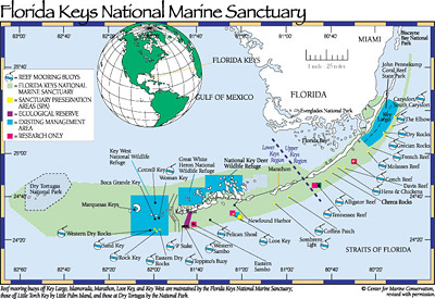
Florida Keys National Marine Sanctuary
The National Marine Sanctuaries Act of 1972 authorized the designation and management of marine environments with special national significance due to their conservation, recreational, ecological, historical, scientific, cultural, archaeological, or educational qualities as National Marine Sanctuaries. Managed by the National Oceanic and Atmospheric Administration’s (NOAA) National Marine Sanctuary Program, these sanctuaries are designed to protect marine resources.
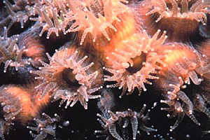
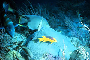
The Florida Keys are known for their coral reefs as well as other interdependent habits including mangroves and seagrass beds. The Florida Reef Tract is home to over 6,000 species of plants, fishes, and invertebrates, including the only coral reef system in U.S. waters. This complex ecosystem is the foundation for the commercial and recreational fishing industries as well as the tourism-based economies that are vital to south Florida.
In 1990, 2,800 square nautical miles (16 square kilometers) of coastal waters surrounding the Florida Keys were designated as a national marine sanctuary. The sanctuary extends in a northeast to southwest arc beginning at the Biscayne National Park for over 200 miles (322 km) to, but not including, the Dry Tortugas Islands. From that point, it turns north and east, covering a large area of the Gulf of Mexico and Florida Bay.
The Florida Keys National Marine Sanctuary utilizes zoning to manage the resources within its boundaries. This zoning helps to reduce user conflicts and to minimize the overall impact to heavily used areas on the reef. Other management techniques are dependent upon the reef, water quality, fish, and invertebrate monitoring data.
For more information, visit: Florida Keys National Marine Sanctuary
Biscayne National Park
Originally established as Biscayne National Monument in 1968, Biscayne National Park is located in Biscayne Bay and the offshore waters along the Atlantic coast south of Miami. The boundaries were expanded in 1974, adding over 8,700 acres (35.2 square km) of land and water. The park was expanded again in 1980 and redesignated as Biscayne National Park.
Currently, it includes approximately 173,000 acres (700.1 square km) of which nearly 165,000 acres (667.7 square km) are waters containing coral reefs while the remaining acreage is dry land including 42 islands. Within the park there are close to 20 threatened and endangered species, including sea turtles, crocodiles, and manatees. This park conserves coral reefs, estuarine habitats, and keys, as well as historic sites.
For more information, visit: National Park Service
Dry Tortugas National Park
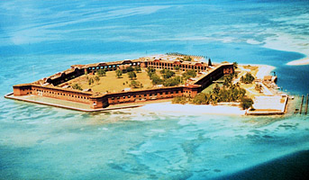
The Dry Tortugas National Park is approximately 70 miles (112.9 km) off Key West. This park includes a group of seven islands composed of coral reefs and sand, called the Dry Tortugas. These islands were first discovered by Ponce de Leon in 1513 and named after the abundance of sea turtles or “tortugas” along with the absence of freshwater as these islands were dry.
During the early 1800’s, the U.S. military began the construction of a massive fort in the Dry Tortugas. However, the fort was never completed due to the invention of the rifled cannon which made this fort obsolete. In 1935, President Franklin Roosevelt set aside Fort Jefferson and the surrounding waters as a national monument. It was later redesignated as Dry Tortugas National Park in 1992 to protect marine life as well as the historical aspects of the area.
For more information, visit: National Park Service
John Pennekamp Coral Reef State Park
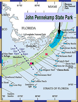
John Pennekamp Coral Reef State Park, located in Florida, was the first underwater park within the United States. Located adjacent to the Florida Keys National Marine Sanctuary and extending into the Atlantic Ocean, this park covers approximately 178 nautical square miles (1.3 square km). Coral reefs, seagrass beds, and mangroves are included within the park boundaries.
Dr. Gilbert Voss of the Marine Institute of Miami observed damage to the reefs off the Florida Keys during the late 1950s. Much of the damage was a result of the collection of coral, shells, seahorses, and other marine life for souvenirs to tourists. He suggested that there should be some restrictions on the exploitation of the reefs to avoid destruction of the reefs.
A powerful ally, John D. Pennekamp had played a major role in the establishment of the Everglades National Park and later became the assistant editor for the Miami Herald. They, along with other conservationists, eventually convinced the Florida Board of Parks and Historic Memorials to designate a 75 square mile (194.2 square km) section of marine habitat as a preserve. Dedication ceremonies were held on December 10, 1960, when Governor Leroy Collins named America’s first underwater park as John Pennekamp Coral Reef State Park. The park was named after John D. Pennekamp in appreciation of the support that had been given by Pennekamp and the Miami Herald.
For more information, visit: Florida Department of Environmental Protection
Glossary terms on page
- archaeological: having to do with the study of material remains from past human activities.
- Florida Reef Tract: the third largest barrier reef in the world, running from the Miami area southwest to the Dry Tortugas.
- ecosystem: a community, including all the component organisms, along with the environment, forming an interactive system.
- endangered species: a species in danger of becoming extinct that is protected by the Endangered Species Act.