Excavations since 1976 at the Fountain of Youth Park (8-SJ-31) have located what we believe to be the site of the Spanish settlement established by Menendez in 1565. Some features at the site may be related to a fortification, however this interpretation is ambiguous.
Historical documents are vague about the first fort at Seloy; it may (or may not) have involved the fortification of a large Timucuan structure near the water’s edge; and those fortifications may (or may not) have included a moat.
The archaeological evidence is also ambiguous. There is no clear evidence for a moat; but there is evidence for a very large sixteenth century wood and thatch building. There is no irrefutable evidence of a large circular council house like that known at the 17th century Apalachee mission site of San Luis but there is clear evidence for a pre-1565 Timucua village occupation, including a series of very large posts.
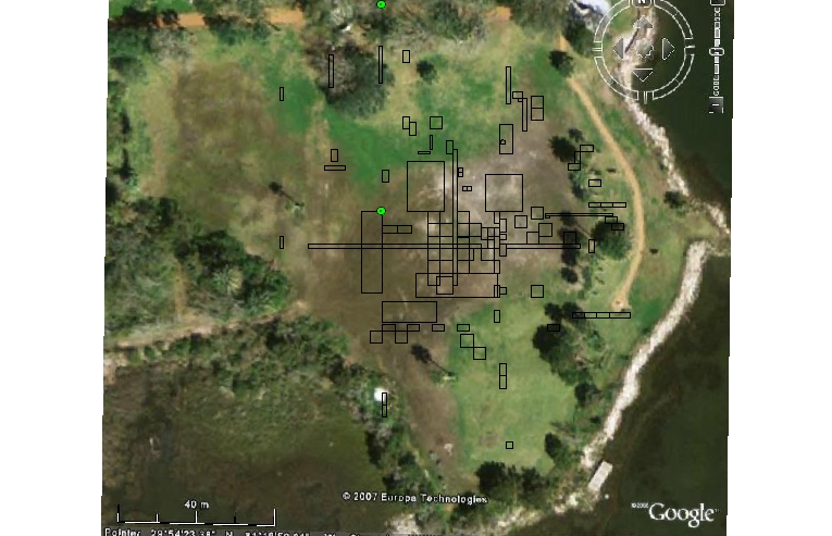
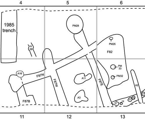
 Locations of archaeological excavations, 8-SJ-31
- Aerial image of the Fountain of Youth Park Site, 8-SJ-31
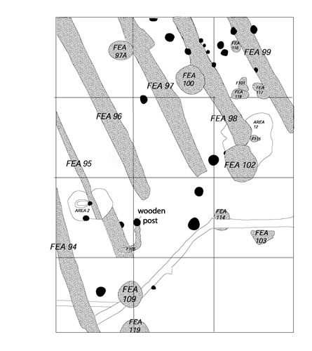
- Timber mud sleeper stains and associated postmolds, Block 4, 8-SJ-31
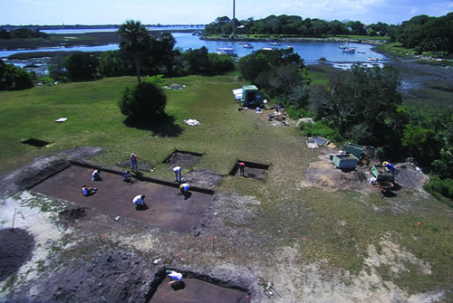
A complicating factor in interpretation is the impacts of nature and human activity to the Menéndez occupation at the Fountain of Youth Park over the past 450 years. The site’s low-lying elevation on the waterfront has sustained countless floods and considerable soil erosion just over the past half century. A dirt airstrip was constructed on it in the 1930’s, and an asphalt road was built around it’s perimeter in the 1950’s. All of these factors probably left only fragmentary archaeological signatures of the Timucua town and the Menendez settlement.
Shovel testing, auger sampling and test pit excavations throughout the property have shown that the sixteenth century Spanish presence at the site is restricted to an area of about 100 meters by 70 meters. It is separated from the moat at 8-SJ-34 (the La Leche Shrine) by some 90 meters of what is today marshland.
- Timber mud sleeper stains and associated postmolds, Block 4, 8-SJ-31
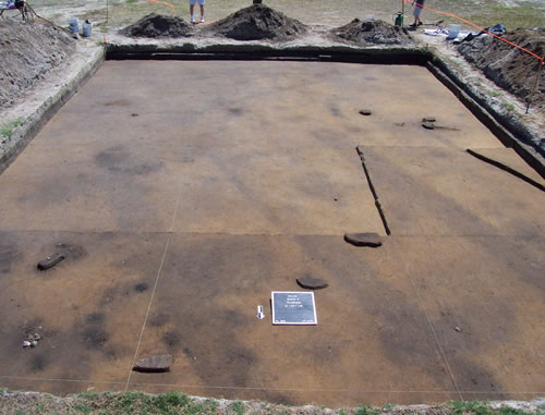
- Sleeper stains from a Menendez-era structure, Feature 87, Block 3, 8-SJ-31
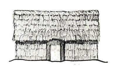
- Artist’s reconstruction of a Spanish thatch structure on mud sleeper sill beams. Drawing by Albert Manucy.
The Spanish concentrated their occupation between two existing pre-Columbian shell middens, which radiocarbon dating has shown to have been occupied for more than 2,000 years when Menendez arrived. The area between the middens, where the Spaniards settled, had been kept free of shell refuse and debris, and appears to have remained so as long as the site was occupied. The Spanish buildings were constructed around this open, trash-free area.
At the northern side of the central Menéndez settlement area, a series of what are believed to be split-log mud sleeper or floor sill stains cover a rectangular area of about 20 by 25 meters. The stains are parallel and about one meter apart, ranging from 50-60 cm in width, and from 15-20 cm in depth. Many of them have a pronounced depression along the east side, as though bearing a heavier load at that point. One potential interpretation of this pattern of stains is as a series of log sills put in place to support a raised wooden floor, a feature that would have been necessary for a storehouse or casa de municiónes. Although there are postmolds are associated with these trenches, they occur at irregular intervals, and if this were indeed a large wooden floor support system, it is likely that the uprights for the wall members were nailed directly to the wooden sills. Such construction is fairly common on European and early Euro-American colonial sites, and would have been sufficient for supporting the palm thatch walls of the Menendez casa de munición.
At the north end of the possible structure, the north-south extending stains are bounded by a slightly larger and more nearly square-shaped stain running east-west. At the south end, the north-south stains do not have an east-west boundary, but instead end at different points, describing an angle. It appears that they abutted an already-existing structure, wall or other obstacle at that point. Whatever it was, it corresponded to the open, trash-free area. It is possible that there may have been a “very large house”, such as that said to have been provided by Seloy, however this cannot be confirmed because the footprint of that building (if it was a building) is no longer intact.
There are several very large postholes which could have been associated with a structure, and might have supported heavy beams or support members. There are also concentrations of smaller postholes dating to both Spanish and pre-Spanish periods, that may once have supported palm thatch walls. If so, they would describe a structure of from 15-20 meters in diameter.
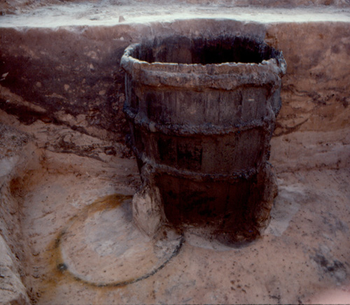
- Menendez-era barrel well, Feature 8, 8-SJ-31
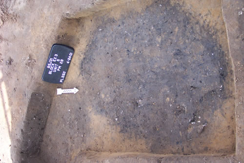
- Major 16th century structural postmold, Feature 30, 8-SJ-31
- One of the large burned postmolds of the Menendez era

There are no timber sill trenches within the central, clear area of the Spanish settlement. They do occur, however, to the south, east and west of the central area or building. These differ from those to the north in that they are narrower, are more rounded in shape, and describe rectangular structures of about 9 by 4.5 meters, some divided into two equally-sized rooms. The contents of the trenches, and the presence of numerous iron nails indicate that these were Spanish buildings, destroyed and backfilled during the sixteenth century.
Two of these structures are associated with Spanish barrel wells. Since wells were not known to or used by the native people of Florida, this further confirms this was a Spanish community. Detailed information can be found in the on-line field reports from these projects.
A line of very large posts was located along the western side of the central area . These were from 50-60 cm. in diameter, and had been dug out and removed during the sixteenth century. Trash deposits covered the hole left by moving the posts, and one particularly rich trash deposit contained not only sixteenth century Spanish pottery, but also rosary beads and a figa amulet, along with other Spanish and native American refuse. It suggests that perhaps the Spanish settlers removed some of the large posts at their original settlement, and used them in constructing the second fort on Anastasia Island. It would certainly have been easier than felling and preparing new timbers.
View artifacts from Fountain of Youth Park