Header image: UF/IFAS Photo by Tyler Jones
The Tampa Bay Climate Science Advisory Panel recently presented area lawmakers with updated sea level rise projections for the region. The new projections are 12 to 18 inches higher on average than the same group’s 2015 estimates.
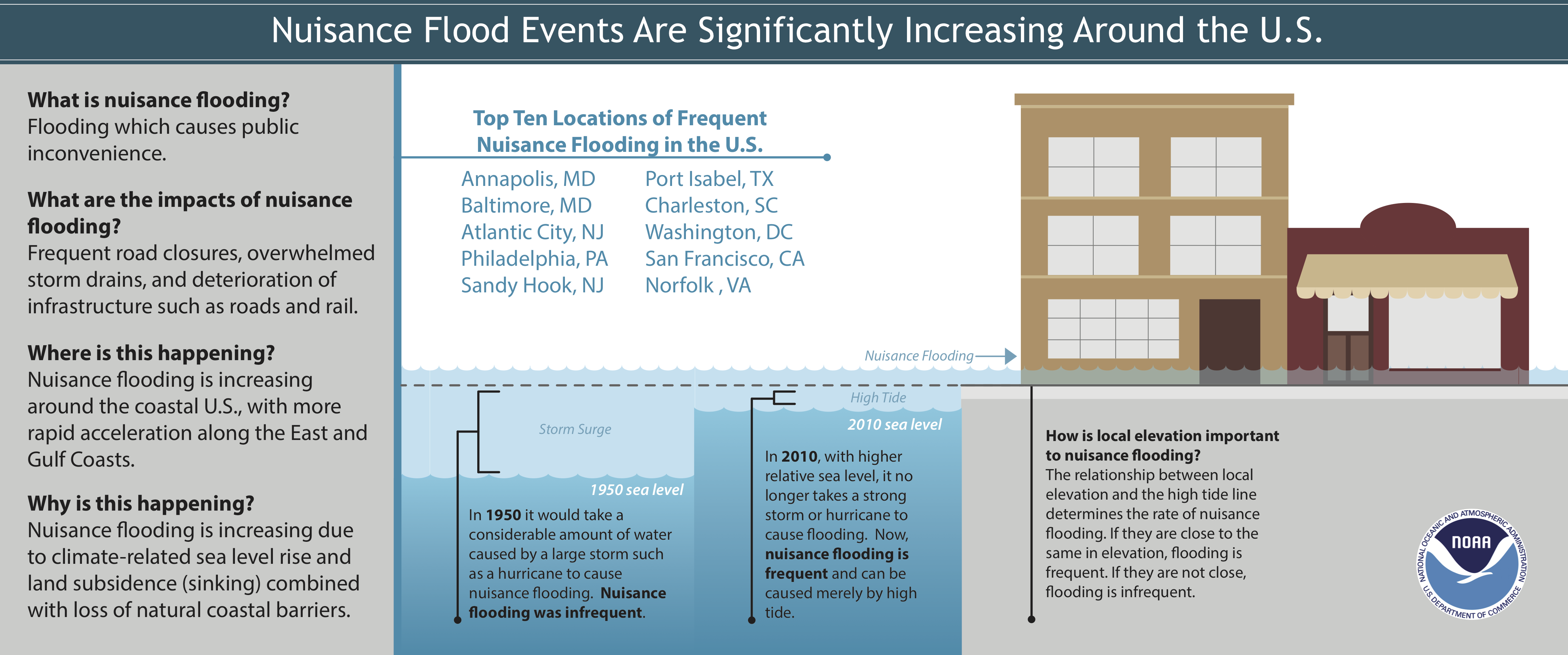
This increase in sea level means that it no longer takes a hurricane or bad storm to cause flooding in coastal cities. Today, routine high tides can result in a phenomenon known as nuisance flooding, which can lead to road closures, overwhelmed storm drains, and a compromised city infrastructure.
According to the U.S. Climate Resilience Toolkit and a 2014 report from the National Oceanic and Atmospheric Administration, coastal U.S. communities have experienced a 300 to 900% increase in high tide-related nuisance flooding compared to 50 years ago. And Florida is no exception.
A 2018 NOAA report states that “the southeast Atlantic coast is currently experiencing the fastest rate of increase in annual high tide flood days, with more than a 150% increase since 2000 predicted in 2018 at most locations.”
How do tides work?
The gravitational pull of the moon and sun cause the daily rise and fall of the sea, also known as tides.
Because the moon is much closer to Earth than the sun, it has a greater gravitational pull on the Earth and therefore more influence than the sun on our tides. This gravitational pull generates a phenomenon known as tidal force. The side of Earth that faces the moon has a stronger tidal force than the side of the Earth facing away from the moon. This difference in forces lead to bulges on either side of the planet, also known as high tides. Tides originate in our oceans and move toward the coastlines where we can easily observe them.
Most tides take place twice a day as the Earth moves through its natural rotation cycle. The landmasses, or continents, restrict the intensity of both high and low tide in different areas. So, the effects may be quite different, depending where you live.
Why are coastal communities experiencing more nuisance floods?
Many factors that lead to more nuisance floods are interconnected. All of these factors alter how water moves through its natural cycle.
Sea level rise
In response to a warming climate, sea levels have been rising at a higher rate than in the past. As water gets warmer, it expands and occupies more space. Melting glaciers and the loss of Greenland and Antarctica’s ice sheets also contribute to rising seas.
Reports from NOAA indicate that in 2014, global sea level was 2.6 inches above the 1993 average, which was the previous record high. Annually, sea levels continue to rise at about one-eighth of an inch.
Land subsidence
Land subsidence is the gradual settling or sudden sinking of the Earth’s surface. According to the United States Geological Survey, land subsidence in the U.S. has impacted, “more than 17,000 square miles in 45 States, an area roughly the size of New Hampshire and Vermont combined.”
More than 80% of the land subsidence in the U.S. is directly linked to over exploitation of underground water. Subsidence can cause local sea level to rise more than the global average.
A recent study by researchers at the University of South Florida and elsewhere examined the impact of local sea level rise and subsidence along the eastern coast of the U.S. The study’s authors suggest that better management practices to limit the over extraction of groundwater from aquifers could reduce coastal subsidence and lead to fewer nuisance floods.
Population growth & urbanization
More than 10% of the world’s population live in areas that are less than 10 meters above sea level. Populations in many of these city centers are continuing to grow at a rapid rate, building more highways, streets, houses and parking lots along the way. These impervious surfaces prohibit water from seeping into the ground and instead redirect it to storm sewers and local creeks, which can lead to localized flooding. In many cases, the flood water overwhelms city stormwater systems.
Loss of natural barriers
Coastal barriers include dunes, barrier islands, and mangrove forests. These natural structures help mitigate the effects of severe storms by absorbing much of the ocean’s energy before it reaches the land.
Nuisance Flooding Lives Up to Its Name
Nuisance flooding can interrupt traffic and transportation, overwhelm sewers, degrade water quality, threaten public health, and hurt the local economy.
Interrupted transportation
Flood-related road closures not only interrupt the flow of daily transportation, but also impact the safety of motorists and emergency responders. Increased water levels can cause vehicles to lose stability and be washed away – increasing the potential for human injury and fatalities.
Increased Risk to Public Health
Nuisance floods can overwhelm sewage systems and cause drainage problems that may degrade water quality, posing a risk to public health. Additionally, puddled water serves as a breeding ground for disease carrying mosquitoes and bacteria.
Economic Burden
The costs of these impacts add up and coastal communities are left to pay the tab.
Over time, the cumulative costs of these floods are comparable to more devastating events such as Hurricane Sandy, according to a study conducted by researchers at the University of California Irvine. In other words, nuisance floods are considered a cumulative hazard. Since nuisance floods are not considered disasters, there are often no funds available to help economically burdened communities.
The study’s authors suggest that providing disaster assistance to at-risk areas could help mitigate the economic consequences of nuisance flooding. But, the authors also say that in order to better understand the impacts of nuisance floods, future research should critically evaluate trends and patterns.
“A promising direction for NF [nuisance flood] monitoring is mining real‐time flood information from social media combined with traffic/security cameras and/or drone imagery. Data records of NF will encourage more research in this area and frame the likely benefits of protection/adaptation measures,” reads their 2018 paper in the journal Water Resources Research.
Learn more about tides and nuisance flooding by visiting the links below:
- NOAA: What are tides?
- NOAA: What is high tide flooding?
- National Geographic: Tide
- Live Science: What causes the tides?
- SciJinks: What causes tides?
- AGU Eos: What is a nuisance flood, exactly?
- UCI News: Over time, nuisance flooding can cost more than extreme, infrequent events
- NOAA: King tides cause flooding in Florida in fall 2017
- NOAA: Nuisance Flooding, Diving Deeper Podcast
- AGU Eos: Engineering climate change resilience into New York subways