Who’s Fault is it Anyway?
Recognizing deformation (faults) of rocks within the Canal on three different scales can give context to the fossils that are found. Who’s fault? Well, that question is a bit harder to answer. We’ll start by looking at the ‘what’.
(1) Outcrop scale (meters/10s of feet) extensional faults reflect regional stress regimes.
When reading geology in the field, one quickly learns that very little in the natural world is ‘random.’ The landscape around us appears inconceivably complex. Yet, the land as we experience it, from the height of mountains, to patterns in vegetation, the angles and shapes of topographic highs, and location of rivers, all that we see results from specific geologic processes (hence, the science of geomorphology).
By learning to identify these processes, one can read the landscape through a fascinating lens of cause and effect.
Take for example, the photograph below: a fantastic example of structural deformation (normal faulting) that has occurred to the sedimentary Canal formations. Here, layers of red and purple and tan sedimentary rocks (the colors most likely a product of iron oxidation) are bounded between bluish grey volcanic tuffs. Notice carefully the geometry which this sequence demonstrates, highlighted by the dotted lines. The central sedimentary sequence is bounded by beautiful 60 degree angles, (somewhat obscured by vegetation), highlighted by the red linear dike (volcanic intrusion) that parallels the dotted line on the right side of the picture.
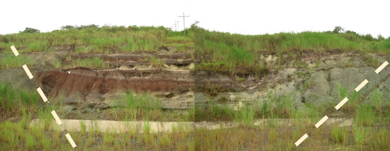
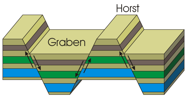
As the schematic diagram illustrates below, the canal sediments in the photograph above display a fine example of extensional faulting.
For comparison, see the following example of a much larger outcrop in Colorado (viewed from the air).
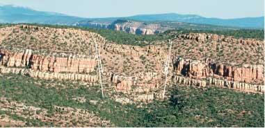
Hard to believe these textbook-worthy events happen on such a large scale? Visit here for more briefing on faulting.
~~~~~
(2) Map scale (kilometers/miles) parallel faults reflect regional stress.
A map of the Panama Canal below highlights an area called the Culebra Cut (also known as the Gaillard Cut, named for the American engineer). It is along this portion of the Canal that the majority of the fossil localities for the PCP-PIRE project are located.
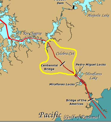
In 1992, the start of the Panama Canal expansion included a 10-year long project to widen the Canal channel as it passed through the Culebra Cut. The broader channel, along with larger locks, was needed in order to accommodate wider PANAMAX vessels. Prior to the work, the dimensions of these ships, built to the maximum size that will pass through a canal lock, limited them to one-way traffic while in the cut.
Follow the link to read more about the Historical Excavation of the Gaillard Cut. For more information on the Panama Canal Expansion, visit mipanamacanal.com.
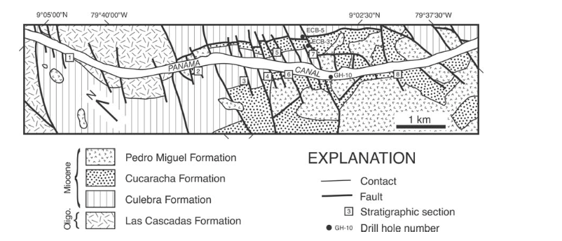
Faulting on the outcrop scale, displayed in the picture of the Las Cascadas Formation at the start of this article, is mirrored in structural relationships on a much larger scale.
Zooming into the structure of formations within the Canal localities, notice how once-continuous belts of rock types are dissected and faulted. The approximate length of this map view is 4.5 miles, and encompasses over 20 major parallel faults.
~~~~~
(3) Hand samples (centimeters/inches) reveal a network of microfaults.
Of the rocks that outcrop along the southern half of the Panama Canal, (the Las Cascadas, Culebra and Cucaracha Formations), almost all are heavily faulted. This is apparent in micro-scale faults within the rocks we excavated (faults with a thickness maybe of several sheets of paper, cross cutting with a density similar to a cracked sidewalk).
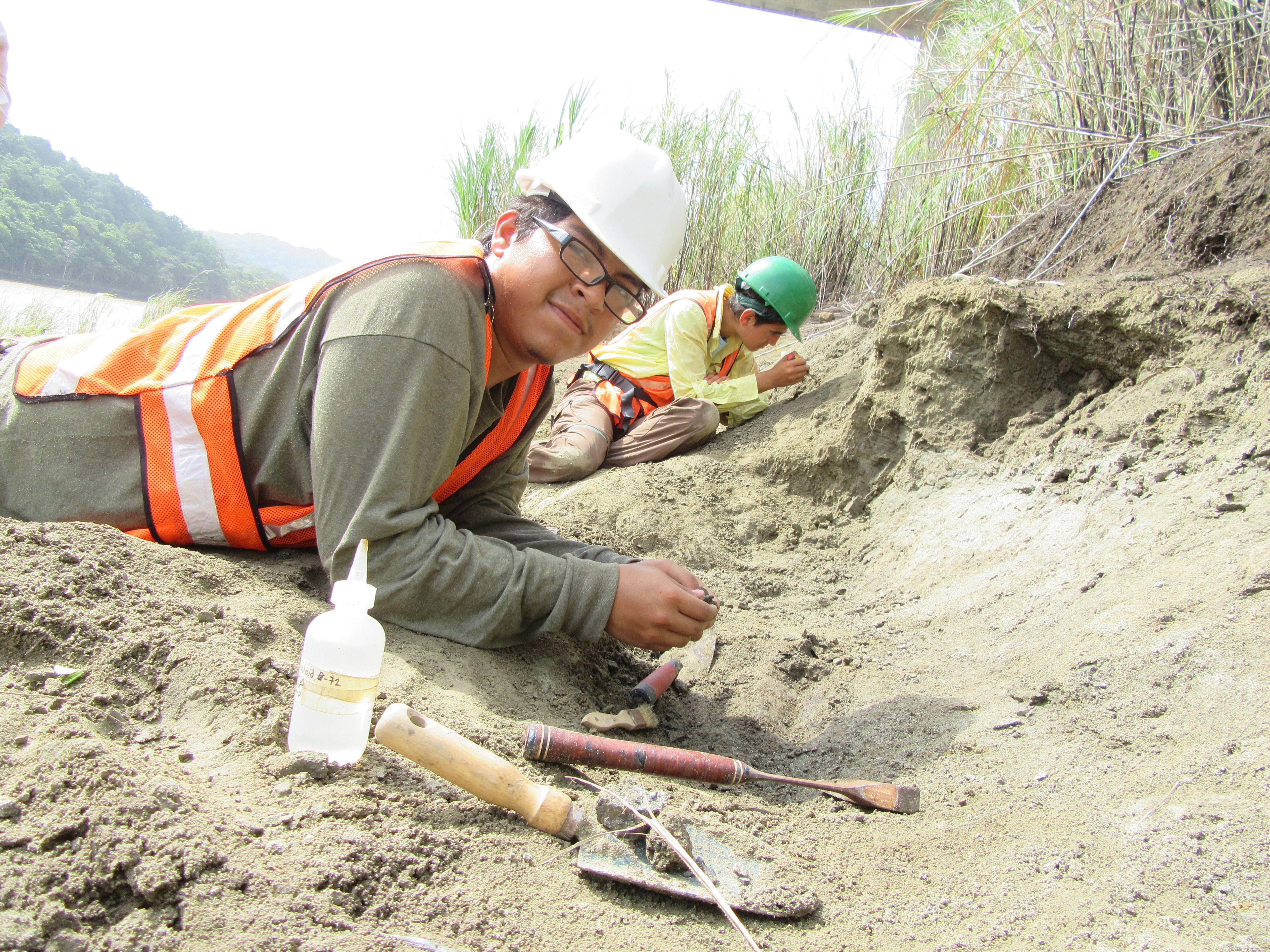
When searching for fossilized remains embedded in bedrock, it is important to understand what has happened to the rocks since their deposition. For us digging in the canal, dark-colored slickenlines and deformation along the fault planes were at first easily confused with fossilized leaves and other remains. We quickly learned the fossils were more difficult to come by!
~~~~~
Rocks along the Panama canal are faulted on a variety of scales, from the order of centimeters to kilometers. It is important to understand this geologic evidence when on the fossil hunt.
And so, to return to our primary question: Who’s fault is it anyway? We’ll settle with the conclusion that all our faults are stress related.
Photography and text original, Gina Roberti. Summer 2015.