The Randell Research Center has grown by five acres with the addition of property containing two Calusa Indian mounds. Thanks to a gift of $150,000 from Tim and Judith Sear and $50,000 allocated by the Calusa Land Trust, a dream has become reality. Land managed by the Randell Research Center now includes about 67 acres.
John Kendall, president of the Calusa Land Trust, said “CLT’s $50,000 donation towards the acquisition of the Smith Mound was its largest gift ever to an outside entity. However, CLT’s Board of Directors deemed this parcel ‘priceless’ and part of our mission. CLT continues to seek partnerships with like minded charitable organizations that also wish to help preserve in perpetuity this precious piece of paradise named Pine Island.” Judith Sear said, “When we heard that there was an opportunity to preserve the Smith Mound and the Low Mound, the opportunity was too good to miss. We are delighted that our Sear Family Foundation funds augmented money already raised and set aside by local residents through the Calusa Land Trust.”
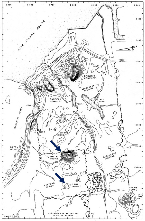
Smith Mound
Smith Mound is not a shell mound. It is made of sand, and is a place of burial, first used by the Calusa about 1000 years ago. It was at least 30 feet high and about 300 feet long. Until 1992, the Smith Mound was just called the “Pineland Burial Mound.” In that year it was renamed in honor of John Smith (son of Capt. John Smith the elder) at the suggestion of Donald Randell.
Originally, the Smith Mound was twice as wide as it is today, and was surrounded by an artificial lake. The western half was taken down in 1916 and used to fill in part of the lake. Ten years later, Graham Wilson owned the property next to the mound, and wanted to tear down the remaining half to use as fill. But John Smith (the younger) prevented the mound from being taken down. At the time, the dividing line between the Smith and Wilson properties ran along the mound cut, the Smiths owning the remaining eastern section of the mound. This property line still marks the eastern boundary of the Randell Research Center, but with the new acquisition, that boundary has been dissolved and the Smith Mound has been reunited with the Pineland Site Complex. The remaining part of the mound is today over 25 feet high and 230 feet long. On the eastern side, part of the surrounding lake dug by the Calusa still exists.
Low Mound
The other mound is called Low Mound. It is smaller, just 10 feet high and 100 feet across. It is made up of sand, charred wood, shells, and animal bones, the remains of meals consumed by the Calusa some 1700 years ago, about the time of the Roman Empire. So it is much older than the Smith Mound. The Low Mound was built up when the shoreline was much farther east than it is today.
The Low Mound was described and sketched by Frank Cushing during his visits to Pineland in May and June of 1895. There was a small pond on the southeastern side, and the entire mound was surrounded by a moat-like feature, similar to Smith Mound.
Significance
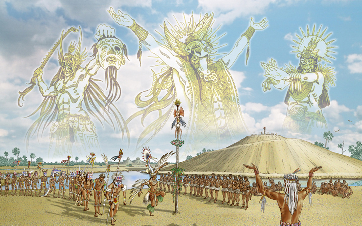
These mounds are important to us for a number of reasons. The Low Mound is of both cultural and environmental significance because it represents an occupation during a warm and stormy climatic episode of interest both to archaeologists and climatologists. Acquisition of the Smith Mound restores the sacred precinct to the site complex. The spiritual life and beliefs of the Calusa Indians are of interest to our visitors. The Calusa people lived at Pineland for many centuries. It is appropriate and fitting that we honor their memory by preserving their place of burial.
What’s next?
Once the invasive vegetation has been cleared away and the fence extended, we can plan additional public interpretation of these components of the site. We need $7,500 for the vegetation clearing, but we already have $5,000 thanks to generous gifts from Bill and Norma Pretsch, John and Gretchen Coyle, and Karl and Kathy Schroeder, so just $2,500 more is needed to get started. Then we must raise $16,500 to extend the fence, then additional funds to design and install new interpretive and wayfinding signs. When we are done, the educational value of the Calusa Heritage Trail will be greatly enhanced.
This article was taken from the Friends of the Randell Research Center Newsletter Vol 14, No. 2. June 2015.