Galt Island rises from Pine Island Sound about 2.5 miles northwest of St. James City. The island originally consisted of 43 wooded acres with a shoreline protected by a thick mangrove fringe. Today a gated causeway connects the island to Pine Island.
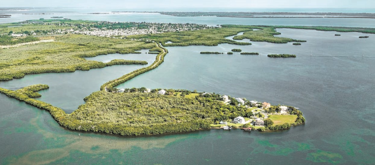
Galt Island homeowners have set aside a preserve to protect the site of a once active indigenous village. There are burial mounds, platforms, and numerous shell middens. There is evidence of continuous occupation from 500 B.C. through A.D. 1710.
Historic Era on Galt Island
According to historian Elaine Jordan, the island’s original name was Goat Island after a resident of St. James City rowed his boat to and from the island to tend his goats. Historians later assumed that Lee County either changed the name or misspelled it unintentionally.
In the late 1950s John Price and his wife Aliese purchased the island and built the causeway. They planned to develop until Hurricane Donna in 1960 removed causeway pieces. The Prices drilled an artesian well, capped in the 1980s, that still flows today.
In 1979, developers purchased the island and requested a zoning change from agricultural to multifamily, potentially allowing highdensity development. At that time, archaeologist Robin Futch determined vandals had destroyed half the burial mound.
In 1981 and 1982, Pine Islanders led a campaign to nominate the island for preservation through the Conservation and Recreational Lands Program. It was on the list when bulldozers cleared nearly four acres of vegetation from the fragile shell middens. The island was about to be stamped with 380 condominium units.
Lee County Commissioners voted to change zoning from ten-units-per-acre to one-unit-per-acre. The developers sold the land, and the result is single-family homes, preservation of waterfront mangroves, and protection for the archaeological site.
Archaeology of Galt Island
“A decided contribution to American archaeology is made in the mere announcement of this Key,” wrote Wells Sawyer, photographer-artist in the Pepper-Hearst Archaeological Expeadition 1895-1896 led by Frank Hamilton Cushing of the Smithsonian Institution.
Sawyer wrote a description of Galt Island as it appeared in 1895, herein paraphrased. Starting on the south side, seven ridges of twelve to fifteen feet in height appear south of a central lagoon. Beyond these ridges are other, low ridges on a platform mound.
North of these is the central lagoon enclosed and protected by elaborately-planned low ridges of shell. North of the central lagoon is a shell mound structure so steep it is difficult to ascend. The top of the steep mound is narrow with two well-defined ridges and a hollow between and traversing its length. On one side is a small lower mound with a level top. Both shell mound structures are comparatively small, the taller being probably eighteen or twenty feet high by maybe thirty feet in length. The mound rises on one side from the central lagoon and on the other from a broad, nearly level roadway leading off north.
Cushing conducted excavations confirming evidence of indigenous occupation. He found no Spanish or modern artifacts. The excavations were hurried and inadequate. He described Galt as a “gigantic shell settlement” to which he wanted to return.
In 1952, archaeologists William Plowden and Floyd Barnes recovered artifacts including types from prehistoric and postcontact periods. By then evidence of vandalism and illicit digging could be seen in the oval, two-tiered, eighty-foot-long burial mound. They recommended site protection and it was listed in the state archaeological site file at that time.
Archaeologists also reported “prone burials in alternating layers of white, black, and red sand, and bundle burials or cremations in small, intrusive pits.” Soil specialists interpreted the sand colors as naturally occurring.
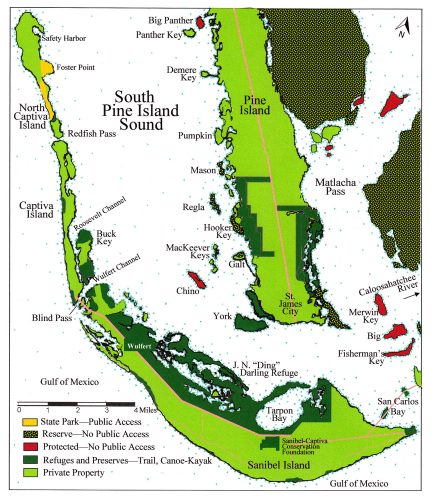
According to archaeologists, the earliest part of the shell midden represented 500 B.C.– A.D. 500. The people of that time were contemporaneous with those on Sanibel Island, Useppa Island, Cabbage Key, Hooker Key, Mason Island, Josslyn Island, Pineland (after A.D. 50), Mound Key in Estero Bay, and at least six other local sites. The evidence suggests that some islands surrounding Galt Island had shell tool workshops.
Today, the archaeological portion of Galt Island is listed on the National Register of Historic places. It is gated and protected by the Galt Island Homeowners Association. They have hosted archaeologists and students from the Florida Museum, University of Florida, Florida Gulf Coast University, and University of California at Los Angeles (UCLA), among others. This was essential for discerning a pattern in Pine Island Sound of several ancient village centers surrounded by smaller island settlements and for the long-term preservation of Galt Island.
This article was adapted from A Tour of the Islands of Pine Island Sound, Florida, by Denége Patterson.
This article was taken from the Friends of the Randell Research Center Newsletter Vol 17, No. 3. September 2018.