The first-time visitor to the Pineland Site Complex is immediately drawn to its impressive mounds, some as high as 30 feet. But veteran visitors know that the high mounds, while important, are only a part of Pineland’s 2,000-year story.
Pineland’s earliest residents, those who lived here between A.D. 50 and 600, built their dwellings at the shoreline, and they did not accumulate high mounds and live on top of them, as later people did.
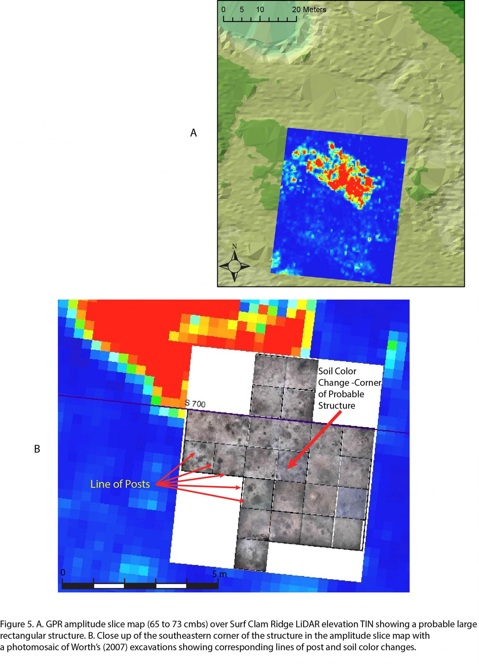
In 1990 and 1992, archaeological trenches beneath the old cow pasture revealed buried middens and some postmolds (stains left by rotted wooden posts). These were documented in detail by Karen Walker (see The Archaeology of Pineland, 2013, pp. 130-134). Another glimpse of these earlier Pinelanders came from John Worth’s excavations in Pineland’s South Pasture in 2003-2004 (RRC Friends Newsletter, March, 2004). With the help of RRC volunteers, John uncovered abundant shells, fish bones, pottery sherds, and shell and stone artifacts, as well as a dark, sandy, highly organic layer indicating intensive human occupation, all dating to the 5th and 6th centuries A.D. As in 1992, numerous postmolds were found, indicating that houses, shelters, or other structures were built there. Underlying levels revealed even earlier occupations, some dating as early as A.D. 230.
Then, in July 2011, a student crew led by Victor Thompson conducted ground-penetrating radar and resistivity surveys on parts of the Pineland site, including the South Pasture where the earlier excavations had been done (RRC Friends Newsletter, September, 2011). These techniques work by sending radar pulses and electrical currents into the ground. Materials under the surface, such as remains of structures, middens, ditches, and other features, can be revealed by these techniques. The data collected by these machines are then processed and patterns can be displayed on a computer screen.
The results are surprising. Not only did the remote sensing detect the middens and structural features seen in the 1992 and 2003 excavations, but it also revealed the remains of what appears to be a large rectangular structure, about 75 x 33 feet, between 2 and 3 feet below the surface of an area we call “Surf Clam Ridge.” It also suggests that smaller structures are located even deeper.
Remote sensing employed on Citrus Ridge showed equally interesting results: remains of several small circular structures about 3 feet below the surface, as well as a secondary canal from the main Pine Island Canal going toward the burial mound.
Although this was a preliminary study, it demonstrates the great potential of shallow geophysical survey at Pineland. Remote sensing will never replace careful hand excavation in archaeology, but it can greatly facilitate our work by offering a “preview” of what may lie beneath the surface. This means that we may be able to learn about Pineland’s earliest people with fewer, but more focused excavations, guided by the images on our computer screens.
This article was taken from the Friends of the Randell Research Center Newsletter Vol 13, No. 2. June 2014.