The CROC Database
The materials in the CROC database stem from excavations carried out at Cerros (Cerro Maya) by David Freidel between 1974 and 1981. Subsequent research by Debra Walker 1993 to 1995 is not included at this time.
Pottery Analysis
Ceramics from the site are organized by surface treatment in the type:variety-mode system commonly used in the Maya region. These include CERAMIC GROUP, a category that includes several related types or CERAMIC TYPE, a single surface treatment. For example, Cabro Group is comprised of slipped, incised, impressed, punctated, trickled and other decoration on very similar vessel forms, each of which has a specific type name. Use the group designation to determine the names of all the related types in the group. Some groups and types found at Cerro Maya are not illustrated in the database, but most have at least a type collection. A list of types organized by ceramic phase is available.
Chronology
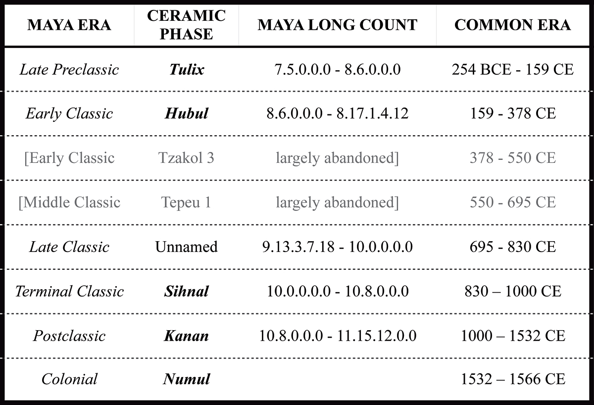
A general chronology for Cerro Maya is available.
Context Specific Searches
Two kinds of special deposit searches are included in the database, CACHES and BURIALS. Caches are intentionally concealed offerings that are generally associated with building renovations at Cerro Maya. Caches in public architecture are labeled numerically 1-17, although some are not included in the database. Small caches in private residences or other features are given upper case letter designation from A through O.
While the burials themselves are not included in the image database, grave goods associated with specific burials are included. Burials are labeled from 1 through 36 although some lack grave goods and some burial numbers were eliminated after laboratory analysis.
Organization of the Database
Images from the CROC database are organized by the SMALL FINDS NUMBER (SF-001 through SF-4370) assigned to each artifact. An artifact is defined as a complete or restorable human produced object. A complete small finds catalogue is available in searchable spreadsheet format.
Manuports (natural objects transported to the site by humans), broken bits of objects (sherds or chert chipping debris) and unmodified animal (bone and shell) or other remains do not have SF numbers. They are recorded by lot using a CERRO MAYA SITE 1 (CM1) number. These range from CM1-00001 to CM1-18498, plus a supplementary series CM1-500000 to CM1-500229. The catalogue is available in searchable spreadsheet format. Due to its large size, it is contained in 10 files organized by CM1 number.
Images of sherds lacking SF numbers appear only in the type collection. RECORD LOCATORS for the Type Collections (TC-001 to TC-067) were created specifically for the CROC database and consist of images illustrative of sherds from a particular pottery type. Most of these images show sherds from multiple lots. In some cases, the original CM1 number is visible written on individual sherds. Type collections are available for inspection in Gainesville, Florida.
Excavation Provenience Detail for the Cerros Project
Cerro Maya excavations between 1974 and 1981 are numbered in two series of OPERATIONS, the monumental core, Ops 1 to 41, and the dispersed settlement, Ops 101 to 163. These can be found in the excavation correlation spreadsheet. Ops have variable horizontal exposure, depending on the goals of the excavation and the architecture uncovered.
Each operation is subdivided into lower case lettered SUBOPERATIONS, generally in 2 x 2 meter increments of horizontal exposure, although this varies by building and context.
The smallest unit of three dimensional provenience is the LOT number, which runs sequentially throughout each suboperation. The lot is defined by the excavator and may be based on natural or arbitrary measures.
Thus, a complete PROVENIENCE designation would be Op 41b-5, where Op 41 represents the operation, b represents the second suboperation within Op 41 and 5 represents the 5th lot within suboperation b. You may search for all the images from a single provenience using this search tool.
Items that were collected on the surface or eroding along the waterfront were given surface find numbers from 1 through 180. These are list at the end of the PROVENIENCE sort, for example, surf-178.
Building Complexes and Levels
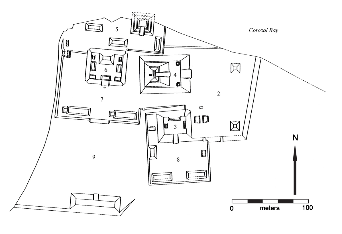
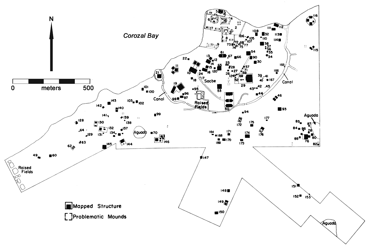
A second set of provenience information is based on the BUILDING COMPLEX number assigned as the site was surveyed. Building Complex, also called Structure Group, numbers run from 1 to 177 and can be located on the site core map and dispersed settlement map. The first uppercase letter A subdesignation following the building number always refers to the basal platform, as in Structure 22A. If there are superstructures on top of the basal platform, these are given further sequential letter designations.
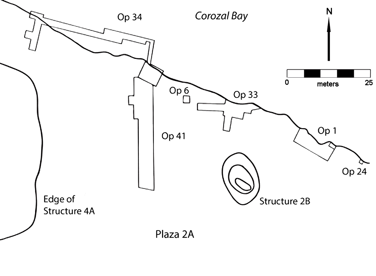
Structure 1 is a special exception. Also referred to as Feature 1 or the Waterfront Village, it is arbitrarily defined as the ground level village floors and buildings located under Main Plaza 2A. Individual structures within the village are given 2A-sub designations, that is, they are buildings below Plaza 2A. There are 24 buildings, mostly burned earth or plaster floors, so far designated within the Village. A map of the main excavations associated with the Waterfront Village is available.
The monumental core, or site core, consists of BUILDING COMPLEXES 2 through 9. These building groups include a basal platform and the superstructures resting on top of it. Structure 6 Group, for example, consists of basal platform 6A plus eight superstructures 6B to 6I, for a total of 9 buildings within the complex. Of those, only 6A, 6B and 6C were tested by the Cerros Project. Structures 6A and 6E were tested in the 1990s.
Excavations in the dispersed settlement (Structures 10 to 177) used the same numeration, but many of the buildings mapped outside the site core consisted of individual mounds. These are all given the alpha designation, as in Structure 98A. Other types of features are given numbers as well, such as Sacbe 1 (126A) and the Canal (127A).
During excavation, natural LEVELS were also determined for each excavation. These are numbered sequentially from the surface (L0) down through the humus (L1) and below. Levels are used to correlate natural stratigraphy within and between excavations. For example, 5A-L3 refers to the third natural level below the surface of Plaza 5A.
Further Information
The CROC database was created by Debra S. Walker, and Susan Milbrath supervised the 3D component developed by Geoff Golder and Jeffrey Vadala. Other collaborators on the project include Lucas Martindale Johnson (photography and drawings) and Carrie Todd (digital catalogues).
For more information on Cerro Maya, see the Bibliography.