The Naval Base at Guantanamo Bay, Cuba, is the oldest U.S. military installation on foreign soil. It was established at the end of the Spanish-American war and celebrated its centennial in 2003. Although it recently was relegated to what the Navy terms “minimum pillar” or its lowest level of operational capability, it has since been resurrected as a detention center in the war on terrorism. The private consulting firm Geo-Marine Inc. was invited to continue environmental surveys on the base to facilitate the development of an integrated management plan. As part of these efforts, an international team of archaeologists and other specialists conducted the first archaeological survey of the base in July 2003, following up on a preliminary survey by Navy archaeologist Bruce Larson, NAVFAC Lant.
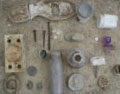
Photo by Bill Keegan
The explosion and sinking of the U.S. battleship Maine in Havana harbor on Feb. 15, 1898, became the defining moment of U.S. interest in Cuba and Guantanamo Bay. In planning its retaliation against Spanish forces in Cuba, U.S. commanders recognized the bay was a strategic location for launching an attack on the heavily garrisoned Spanish forces in Santiago because the lower bay lacked large towns or cities due to the lack of a reliable potable water source. A battalion of Marines established a base on the hill above Fisherman’s Point on June 10. After being harassed by Spanish guerillas for several nights, the U.S. forces attacked the Spanish headquarters at Cuzco Well on June 14. The Marines gained strategic advantage when they captured the horseshoe-shaped ridge that overlooks Cuzco Beach. The Marines attacked the Spanish forces from this western ridge, and, with artillery support from the U.S.S. Dolphin, displaced the Spaniards who retreated to Guantanamo City.
The Spanish headquarters was burned, and the well was filled-in to deprive Spanish troops of a water source should they try to reoccupy the area. The bay then provided a base of operations from which U.S. forces were able to first capture Guantanamo City, then control the railroad lines, and finally defeat the Spanish at Santiago de Cuba. The archaeology team’s first order of business was locating the Spanish headquarters. We surveyed the surrounding hills by shuffling up tracks that were used into the 1980s to drive tanks to the top of the ridges. Along the beach we found the fragments from half of a prehistoric vessel, evidence that Amerindians had lived on the bay, along with historic ceramics from the Spanish and later periods. But the major find was historic materials at the foot of a hill, including nails that were fashioned into fishhooks and a large pile of roof tiles, near a limestone foundation and well, marking the Spanish headquarters.
We then moved to the northern boundary of the base. The drill was the same most mornings. At 7 a.m. we would arrive at the Marine barracks where project director Tim Sara would check us in and collect our armed Marine escort. An escort is required in the unlikely event that we came upon Cubans who had managed to cross the fence line, or in case unexploded ordinance were encountered.
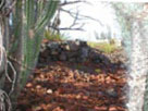
Photo by Bill Keegan.
Driving north we passed Camp X-ray where enemy combatants were initially housed, to the northeast gate, the portal to Cuba that was closed after Castro came to power, and along the perimeter fence that marks the northern boundary of the base. U.S. Marines in observation posts watch the border while Cuban observation posts watch the base.
We often heard music blaring from the COPS, and we were regaled with speeches on Cuban Independence Day. It was out here, on North and South Toro Cay, that the original base was established. The foundations of many of the original structures are still visible. They present a fascinating time capsule. This part of the base was only in operation for four years (1904-1908) before the Navy relocated operations nearer the mouth of the bay to take advantage of the better deep-water channels and anchorage locations for the fleet. Historical descriptions allowed us to identify most of the structural remains, and we recorded and collected associated historic materials.
Most of our investigations involved walking around the low ridges that jut into the bay. Amerindian peoples who used this area left behind light scatters of stone tools and the broken remnants of pottery vessels. These scatters are evidence of short-term activities and no large village sites were encountered. The absence of permanent settlements reflects the very arid climate of the base. For although dark rain clouds form over the Sierra Maestra Mountains every afternoon, the base is too far south to benefit from the daily showers.
This lack of permanent settlement mirrors the descriptions made by Christopher Columbus when he visited the bay in April 1494. Columbus was amazed by the size and beauty of the bay, yet he encountered only a small group of natives collecting fish and iguanas for a feast that was being given by their chief.
Despite the college-campus appearance of the base and modern amenities (including a McDonald’s), our daily trips to the little used northern reaches were like a trip back in time. The low desert vegetation is punctuated by all manner of thorny shrubs and cacti. Large iguanas raced for their burrows as we approached and the cat-sized rodents, called hutias (locally known as banana rats due to the shape of their droppings), watched us warily from the trees. On most islands (and on the other side of the fence line) these animals have been trapped into near extinction, but the base provides a safe haven. Our work contributes to a management plan that continues to conserve these native species along with the natural and cultural heritage of this tiny slice of Cuba.
William Keegan, Ph.D. is Curator of Caribbean Archaeology at the Florida Museum of Natural History. His research focuses on the native peoples of the West Indies prior to the arrival of Europeans, with an emphasis on social and economic relations. Since 1978, he has directed archaeological research projects throughout the West Indies, including the Bahamas, Turks and Caicos, Grand Cayman, Cuba, Haiti, Dominican Republic, Jamaica, Grenada, Trinidad, Puerto Rico and St. Lucia. This article was approved for publication by the U.S. Navy.