On May 14, 2005, at the 57th annual meeting of the Florida Anthropological Society in Gainesville, Merald Clark, John LoCastro, Darcie MacMahon, John Worth, and we will present for the first time a revised map and interpretations of what we think the Calusa town of Pineland looked like at the point of Spanish contact.
Our new map is based on excavations, interviews, aerial photographs, and recently discovered documents.
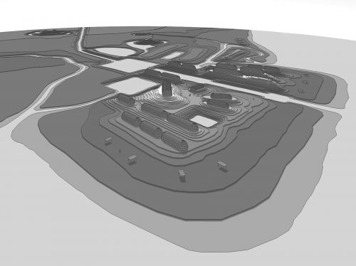
In 1999, archaeologist Phyllis Kolianos found an unfinished Florida manuscript of Frank Cushing’s in the Smithsonian’s National Anthropological Archives. Contained within it was a much longer and more detailed description of Pineland than had been published by Cushing in 1897. Phyllis also traveled to the Southwest Museum in Los Angeles, where she found two sketch maps of Pineland drawn by Cushing. She found a third map of Pineland at the Brooklyn Museum of Art. The new documents are now available in a two-book set published by the University Press of Florida.
Thanks to Phyllis’s excellent detective work, we all have much more information on what Pineland looked like just before the twentieth century began. Adding this new knowledge to our previous data, we now envision a much more complex Pineland site and a repositioned canal route. John LoCastro of Synergy Design Group digitized our new map and modeled it in three dimensions. This helped us to select views to be transformed by Merald Clark into scenes of sixteenth-century Pineland life. These are featured on the interpretive signs of the Calusa Heritage Trail (see Friends of the RRC Newsletter Vol. 3, No. 4, December 2004).
This article was taken from the Friends of the Randell Research Center Newsletter Vol 4, No. 1. March 2005.